
Geostatistical Seismic Analysis and Hazard Assessment for Israel
Results
The Seismic Hazard Zone Map (SHZM) generated from this project's ArcGIS analysis (Figure 1) distinctly delineates the risk levels across different zones in Israel: 'High', 'Moderate', and 'Low'. The western parts of Israel, further from the fault line activities of the 'Cyprian Arc' in the north and the 'Dead-Sea Rift' in the east, and closer to the Mediterranean Sea, are categorized as low-risk areas (green). Conversely, areas proximate to the 'West Bank' region, specific northern locations, and most of the southern part of Israel are deemed high-risk (red), with the remainder of the territory being moderate risk (yellow).
The population risk level graph (Figure 2) reveals that a majority of the population, 63%, reside in areas considered "risk-free," being situated away from seismic activity. About a fifth of Israel's population, living close to the eastern fault line, from the north down to the south, are at the highest risk. An additional 16% face a moderate level of risk (yellow). moderate, yellow)
Discussion
The findings from the SHZM validate the initial hypothesis that zones closer to the eastern and northern fault lines would exhibit higher risk levels. Unexpected was the extensive 'High' risk area identified in southern Israel, potentially attributable to seismic movements along the African-Arabian tectonic plates. This discrepancy could also reflect limitations in the project's classification and ranking methodology, suggesting that a more nuanced classification or altered weighting in the overlay analysis might yield different outcomes.
The analysis partially confirms the second hypothesis, suggesting that the majority of Israel's population, residing near the Mediterranean Sea, would be at lower risk. Nonetheless, methodological choices in ranking and classification may have influenced these results.
It's critical to acknowledge that, despite 63% of the population residing in low-risk zones, the potential for a catastrophic earthquake, as predicted to occur every 100 years or so, places everyone at 'high' risk. The nature of such earthquakes means their effects could be felt across Israel's narrow width of 150 km at its widest point and length of 500 km from north to south.
Future research directions include refining the methodologies and models used to produce a more accurate SHZM, reassessing Israel's current laws and regulations regarding infrastructure and building construction for potential improvements, and reevaluating the government's earthquake and tsunami emergency plans in light of new data from the SHZM or similar projects.
Figure 1: Israel Seismic Hazard Zone Map (SHZM)
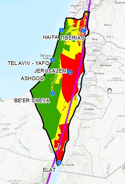
Figure 2: Israel population by Area risk level obtained from the SHZM layer
